Showing posts with label park. Show all posts

Tuesday, November 12, 2019

A Rare Photo Shoot With a Friend

Collaborating

If there is one thing you have probably noticed about me is that I tend to shoot alone. There are very few times when I get together with another photographer and virtually never a group. It's not that I am particularly anti-social but I value my solitude and, honestly, most of my shoots are last minute events. That is not to say I am always alone, my wife and I enjoy going out to parks and I will shoot. My son has also accompanied me on a couple occasions recently. This past Monday was one of the rare exceptions.

Jim and I grew up in the same town and have known each other forever. I think Monday may have been the first time we have seen each other in more than 40 years.... I've been meaning to get together with Jim for a while and we even had a shoot scheduled once before but I had to cancel. I sent Jim a quick message on Sunday to see if he was available to shoot a sunset, fortunately he was.

Where Should We Go?

I checked Clear Outside1 to see what kind of conditions we could expect for the sunset; it was calling for 98% high cloud coverage. That isn't good but it's better than low clouds - at least we had a fighting chance of some color. Luck was on our side because the full moon was appearing on Monday, this gave up a second opportunity for images. I decided on Chestnut Point at Manasquan Reservoir because I knew we would be able to come away with some images even if the sunset was a bust. A quick check with MoonCalc1 showed me that the moon was rising at just about the same time as the sun was setting. I was actually looking forward to the rising moon than the setting sun.

So Many Compositions!

This was Jim's first time at the reservoir and I wanted to make sure he came away with some good images so I arrived a little early to look around. I have shot here before (Manasquan Reservoir - A Sunrise & Sunset Weekend) but things change with the water level of the reservoir, dramatically changing the landscape at times. It didn't take long to find this little pool of water, the water was almost mirror smooth making a nice contrast with the small waves in the reservoir. It has a nice foreground, too.

We broke out our tripods, set up the cameras and waited for the show to begin. It was nice catching up after all this time and having someone to pass the time with while waiting. As the sun was setting the reality hit - we weren't going to get the amazing sunset that I was hoping for. The cloud cover was just too thick, although there was a nice red glow around the Environmental Center, just no decent composition to go along with it.

This is one reason I don't often invite others - it is one thing to drag myself out and leave empty-handed but it is another thing when you drag someone along with you and they come away with nothing. I think that is one reason why I haven't done any workshops....

It is a beautiful and delightful sight to behold the body of the Moon. – Galileo Galilei

The Silver Lining

As it became clear that sunset was a bust I was desperately looking for something to salvage the excursion. That is when the moon made it's first, faint, appearance over the distant trees. Okay, we are going to witness something special if the moon peeks thru the clouds for us. We stayed where we were but turned the cameras slightly to the north and awaited our chance. I took a couple shots but decided there was too much foreground and that moving closer to the water would make for a better composition. I don't want to brag, but I was right.... 😉

The word of the day was "bracket" and I did. The last time I had the moon in a landscape I ended up with little more than a bright orb in the sky. I knew I wasn't able to get a well-exposed moon and well-exposed landscape so I went to far extremes in exposure; the plan is to use blending in Photoshop to come up with a good composite image. I will do that at a later date and dedicate an entire post to composites and exposure blending. The images shown here are all processed from a single exposure - there was no HDR or exposure blending used.

In the end, I think I walked away with a few reasonably good images and hope that Jim did the same. I haven't seen his work yet but hope to soon.

At The End of The Day

When all is said and done, I'm glad that I invited Jim to join me for a shoot. The intended purpose of the get-together was for me to deliver a calendar to him and we originally were going to meet at my office for the exchange. I had to cancel that somewhat last minute and it turned out for the best.

I may have to re-think some of my planned outings and change them from solo outings to collaborations. Only time will tell.

Thanks for stopping by, I hope you enjoyed the story and images. I would love to hear your stories about plans that go awry but turn out better than expected. Leave me some comments below. Thanks again!

1 I wrote about Clear Outside and MoonCalc in Manasquan Reservoir - A Sunrise & Sunset Weekend. I will be writing full reviews after I spend more time working with them.


Tuesday, November 5, 2019

Parks of Monmouth County - Manasquan Reservoir

Manasquan Reservoir

Welcome to another installment of my series - Parks of Monmouth County. In this installment I will be discussing Manasquan Reservoir in Howell. There are three (3) parking areas, Chestnut Point, Environmental Center and Visitor Center, each providing access to one or more trails and each affording their own incredible views of the reservoir.

The thing that draws me to the park more than anything else would be the dead trees in and around the water. It can be difficult to find interesting compositions of large lakes but the trees are perfect, as are the rocks around the perimeter of the reservoir. The trees make great subjects for silhouettes, like in the black & white image below.

The Trails - Environmental Center

Bracken Trail

I just recently discovered the Bracken Trail, it made for a nice hike after work. It is a half-mile Pedestrian Only, EASY, trail with informational placards describing the flora and fauna you are likely to encounter during your hike. There are a few spots along the way that afford a wonderful view of the reservoir.

Cove Trail

The Cove Trail is a 1 mile, MODERATE, trail bringing you thru the wetlands near the Environmental Center. This is a Pedestrian Only trail. This was the first trail I hiked at the reservoir and enjoyed it. There are some small grades and the trail is a bit rough at times; you have to watch for roots and rocks and the trail can be narrow in spots.

The Trails - Visitor Center

Bear Swamp Connector

Bear Swamp Connector is a .7 mile EASY trail that connects the reservoir to Oak Glen Park, a Howell Township municipal park. This is the only trail that I haven't hiked and so I don't know anything about it.

Wetland Spur

The Wetland Spur is a .2 mile trail connecting the Visitor Center parking lot with the Perimeter Trail. This is the trail that I most frequently find myself as there is a small bridge that affords terrific views on both sides. If you are a photographer, this is one of the best places to explore. There are endless compositions and the landscape is ever-changing.

Perimeter Trail

The Perimeter Trail is a 5.1 mile MODERATE multi-use trail. The trail is reasonably flat and well-maintained, you still need to be mindful of rocks and roots because you will be in the woods for much of the way around. The trail starts at the Visitor Center although you can enter the trail at any of a number of places. If you start at the Visitor Center and hike counter-clockwise, you can use the mileposts along the way to track your progress.

Other Activities

Boating & Fishing

Boating is permitted, including boats with electric motors. Boat rentals are available, in season. If you bring your own boat, there is a launch fee - check website for current fees and restrictions. All boaters must wear approved personal flotation devices at all times on the water.

The reservoir is stocked with large and small-mouth bass, hybrid striped bass, tiger muskie, bullhead catfish and various species of panfish. A valid New Jersey freshwater fishing license is required for all fisherman between the ages of 16 and 69.

Biking

Bikes are allowed on three (3) of the five (5) trails - the exceptions being Bracken & Cove trails and rentals are available at the Visitor Center between May 23 and October 30, weather permitting. Of course, you are welcome to use your own bicycle but remember, the trails are unpaved so leave your expensive road bike at home.

Playground

There is a nature-themed playground near the Visitor Center for children.

Environmental Center

The Environmental Center has something for everyone, including nature programs, interactive exhibits and a live view of a bald eagle nest. If you want to do some exploring on your own, you can get a free "Safari Backpack" to help you with your self-guided nature walk. The backpacks are free but you need to leave a valid New Jersey drivers license. The programs at the center are free and many are "self-directed" - check the website for dates and times as they change.

The Environmental Center is open for area groups, offering a wide-range of activities, including boat tours and kayaking. You can get more information on the Environmental & Outdoor Education Programs for Groups page.

For a full list of the series, with links, check out the "Parks of Monmouth County" page.

How to get there

  • Garden State Parkway to Exit 98, Interstate 195 west. Proceed on I-195 west to Exit 28B, Rt. 9 north-Freehold. Stay in right lane when entering Rt. 9 north. At first traffic light, turn right onto Georgia Tavern Road. Follow Georgia Tavern Road for 0.3 mile. Continue straight for Environmental Center on right or turn right onto Windeler Rd. and continue 1.5 miles to the Visitor Center Reservoir Area on left.
  • State Hwy. 9 south from Freehold to Georgia Tavern Rd. Use Jughandle to turn left onto Georgia Tavern Rd. Proceed as above.


Saturday, October 26, 2019

Parks of Monmouth County - Turkey Swamp Park

Turkey Swamp Park

Welcome to the third installment of my series - Parks of Monmouth County. I have come to fall in love with Turkey Swamp Park over the past few years. The park is rather unique from all the others in the Monmouth County Park System in that it is the only park to post warnings about black bear. I don't recall reading about any bear sightings at the park but the brochure and park bulletin board issue warnings.

Turkey Swamp Park is a wooded park just under 2,300 acres in size located in Freehold with something for everyone. There is a 17-acre lake for fishing, boating and ice skating; you can bring your own boat or rent a boat, canoe or kayak. Please note that there is no boat ramp and you must carry your boat from the parking lot; no gas motors, electric motors are permitted. If you plan on fishing and are between the ages of 16 and 69, you must possess a valid New Jersey Freshwater Fishing License. If camping is in your future, Turkey Swamp is a great place to stay. They have two (2) different camping areas, one for Family camping and another for Group camping. I have camped a few times in the group area when my son was in Cub Scouts and had a great time. The main attraction, for me at least, are the trails. There are seven (7) trails of EASY and MODERATE difficulty ranging in length of about a mile to 2.5 miles. I have hiked the three EASY trails more than once and hope to get to the other three trails in the coming months. Lastly, there are a number of picnic areas, a couple playgrounds and the main Shelter Building. The Blueberry Path & Metedeconk Trail are accessible from the Nomoco Activity Area while all others are directly accessible from the Main Entrance on Georgia Road. The northern trail head for the Metedeconk Trail is accessible via the Link or Fitness Trail. I will have links to brochures you can view or download at the end of this post.

The Trails

Turkey Swamp Park, like most (all?) of the other parks, offers a Fitness Trail. I am not going to write about it as I haven't used the trail but wanted to mention it. It is a 1 mile trail along the outside of the big field on the west side of the park. There are 20 stations, each representing a different exercise or stretching regimen. I've also not hiked the Metedeconk Trail (1 mile MODERATE) or Blueberry Path (1 mile MODERATE) so I won't be writing about them. I will, at some point, hike and write about both. Stay tuned!

Alder Trail

The Alder Trail is a 1.6 mile EASY trail that takes you all around the lake. This is the trail I hike most often - if you can only hike one trail, make it this one. The trail takes you thru the Sandy Run Picnic Area which is where you would have found the boat dock shown in the image above (see Endnote below.) While the trail is rated as "easy" you need to be vigilant while hiking thru the wooded sections and keep your eyes on the trail in front of you - roots and stumps litter the trail and it is easy to trip over one. While hiking the trail you will come to a few spots that afford a wonderful view of the lake, if you approach quietly and keep an eye open you might catch a glimpse of a great white egret or great blue heron. Of course, spotting deer on any of the trails is always a possibility, particularly when you get to the big field on the east side of the lake.

Old Lenape Trail

The Old Lenape Trail is another 1.2 mile EASY trail, this one is entirely wooded and takes you around the Family Campground. The trail is named for the Lenape Indian tribe who were indigenous to the area. As with the Alder Trail, keep a lookout for rogue roots, stumps and rocks that can trip you up along the way. I have hiked this trail a few times and always found deer along the way; the woods can get a bit thick at times and often I didn't know the deer were there until I caught a fleeting glimpse of them running deeper into the woods. As you can see from the image to the left, the woods are a mix of evergreen and deciduous trees and most of the area is covered in a lush carpet of leaves and needles. I love finding intimate scenes like this while hiking, landscape photography isn't always about the grand vistas and sweeping panoramas. To me, this image captures the essence of being in the woods in autumn - no better place nor better time of year.

Link Trail

The Link Trail is a .7 mile EASY trail that allows you to extend the length of your hike by acting as a "link" between Old Lenape Trail and Metedeconk Trail or Fitness Trail. The second time I hiked Old Lenape I took the Link over to the field, followed the Fitness Trail to Alder Trail and back to the parking lot. It made for a nice, long hike with a varied environment.

Manasquan Trail

The Manasquan Trail is a 2.5 mile MODERATE trail that starts on the Alder Trail, runs north and connects with the Old Lenape Trail on the way back. Though the trail itself is 2.5 miles, the entire hike is considerably longer - I hiked it for the first time this week and I covered just over 4.3 miles. I started at the Shelter, took the Alder Trail to Manasquan Trail and then back to the shelter via Old Lenape Trail. This is another heavily forested trail which runs along the Manasquan River in sections. The trail definitely deserves it's MODERATE rating due to some of the terrain and it's length. There are a couple small uphill grades but they are gradual and not very long. The trail, for the most part, is well defined and wide but it does become nothing more than a narrow passage shortly before you get to the river at the furthest point of the trail.

Metedeconk Trail

The Metedeconk Trail is a 1 mile MODERATE trail beginning at the Nomoco Activity Center. I haven't hiked this trail yet so I will refer you to the brochure for more information about it.

Blueberry Path

The Blueberry Path is a 1 mile MODERATE loop at the southern most section of the Nomoco Activity Center. I haven't hiked this trail yet so I will refer you to the brochure for more information about it.

Endnote: The wooden dock shown in "Early Fall Panorama from Boat Dock" is no longer there. It has been replaced by a larger, fiberglass dock and the trail leading to it has been enlarged.

For a full list of the series, with links, check out the "Parks of Monmouth County" page.

Brochures

How to get there

  • NJ Turnpike to Exit 7A to Interstate 195 east. Follow I-195 east. Follow I-195 to exit 22. Turn left onto Jackson Mills Rd. north. Follow Jackson Mills Rd. to Georgia Rd., turn left and follow 1.7 miles to main park entrance.
  • Garden State Parkway to Exit 98 to Interstate 195 west. I-195 west to Exit 22. Turn right onto Jackson Mills Rd. north; follow Jackson Mills Rd. to Georgia Rd.; turn left and follow 1.7 miles to main park entrance.
  • State Hwy. 9 to route 524 west. Follow 524 west to Georgia Rd., turn left and follow Georgia Rd. 1.7 miles to main entrance.
  • Nomoco Activity Area Is located 1.5 miles past the main park entrance. Continue south on Georgia Rd. to Nomoco Rd.; turn right and follow signs to Activity Area.


Monday, October 7, 2019

Parks of Monmouth County - Thompson Park

Thompson Park - Lincroft

Welcome to another installment of my series - Parks of Monmouth County. I started this series in May 2017 with the intention of writing about a different park each month - well, life got in the way and I got involved with other projects so I fell a bit behind. I will try to bring more in a more timely manner. 🤞
For a full list of the series, with links, check out the "Parks of Monmouth County" page.
Thompson Park has been the scene of several other posts in the past (I will list a few at the end) but I have never written about the park, in general, until now. The park is located on Route 520 (Newman Springs Road) in Lincroft, adjacent to Brookdale Community College. I worked about three miles away for a while in 2011/2012 and used to go to the park quite a bit - most lunch hours and often after work. There are a number of wooded trails that I enjoyed hiking thru, as-well-as paved trails. If you are quiet and remain alert, you are almost guaranteed to come across deer and, if you are lucky, a good-sized buck like the one shown here. I came across this guy during one of my lunch hikes, I had no idea he was there until something caught my eye - I turned and was able to grab a couple shots before he turned and ran off.

Trails

The trail here is the Track Loop, an easy 1 mile oval that is a favorite for runners. You can branch off this trail onto the Wanderer Trail which brings you into the field and is a nice little change from the dirt trail. If you are looking for a quick, wooded hike check out the Woodland Trail and consider taking the Marshy Walk along with it. The hawk shown here was taken on the Woodland Trail.

My favorite trail is the longer (4.8 mile) Reservoir Loop which runs from one end of the park to the other, most of the time surrounded by woods. There is the Swimming River Reservoir on one end and Marlu Lake on the other and you are almost certain to come across deer in your travels. The buck shown above was taken on the Reservoir Loop and the geese were on Marlu Lake. If you want an easy, paved trail for a leisurely walk you can try the Inner Loop or the Thompson Loop, 1.2 miles and 4.2 miles respectively. The Thompson Loop runs along the perimeter of the park and along local roads - it is ideal for walking or bike riding. All of the trails are rated as Easy or Moderate.

Wildlife

While I am mainly a landscape photographer I am drawn to the wildlife at Thompson Park more than the landscape. The park is quite beautiful but my money is on the hawks, deer and other fauna that I routinely come across. I don't think there was a single hike where I didn't encounter at least one deer and I always see hawks; though the close encounter depicted here is very rare.

There was one hike that afforded me the chance to photograph a garter snake and the lake is always alive with waterfowl - whether the geese shown here or ducks. The lake provides an opportunity to fish, whether from the shore or boat. You may bring your own boat or rent a canoe or kayak, either way, don't forget your freshwater fishing license.

Recreation

Hiking and fishing aren't the only activities available - there are picnic areas, a playground, open fields and even an "off-leash" dog area. If you want a workout, you can play tennis or pickleball on one of four tennis courts or reserve one of the athletic fields for a game - Ultimate, maybe?

The Visitor Center is housed in the mansion not far from the park entrance where you can pick up information abut the park and check out some of the exhibits. Finally, the Creative Arts Center offers many programs for people of all ages and skill levels - I suggest checking out the website to see what activities are scheduled.

In Closing

It should come as no surprise when I say that Thompson Park should added to your regular rotation. There is something for everyone, any time of year. I would caution you to check the park's website during deer hunting season because it is closed to the public during certain hours of the day.

If you have been to the park, let me know what you love about it. If you have a park that you think I would enjoy or that you would like to see me write about, leave me a comment below - I would love to hear from you.

Links

How to get there

From the North:
  • Garden State Parkway to Exit 109, turn left onto Rt. 520 West, 2.2 miles to Park (past M.T. Thompson park and Brookdale College entrance ) on left.
  • State Highway 34 to Route 520, turn left. Follow Rt. 520 east to Park entrance.

From the South:

  • Garden State Parkway to Exit 109, turn right onto Rt. 520 West (Newman Springs Rd.), 2.2 miles to Park (past M.T. Thompson park and Brookdale College entrance ) on left.
  • State Highway 34 to Route 520, turn right east to Park entrance.


All photos are copyright Joseph S. Valencia All Rights Reserved They may not be used in any way without express written permission of the photographer. If you wish to use any of the photos you may contact the photographer at valencia32photo@gmail.com

Thursday, February 7, 2019

Some of my Favorite Lakes in Monmouth County

A few of my favorite lakes

My wife was looking thru her Facebook feed the other night and came across some pictures that a friend posted. There were some swans on a lake (but it wasn't Swan Lake.... 😂 .) She showed them to me and asked if I knew where the lake was, she seemed to think it was Belmar. I looked and it seemed more like a small lake in Ocean Township - after we guessed a couple times she asked her friend; we were both way off! The lake is in Brick. My wife then asked if I had written any blog posts about lakes; realizing that I had not, I silently vowed to write one.

I don't know why I haven't done this before, I have shot around many lakes - some of which are very special places to me. Looking over my previous 76 posts I realized I haven't written about a single lake, their images have appeared in posts but I've never written about the lake or highlighted it specifically.

Lake Topanemus

Lake Topanemus is located in Lake Topanemus Park in Freehold. I have done a lot of hiking and shooting in this park over the last few years. It used to be my "go to" spot for lunchtime hikes but don't go there as much anymore, seems like there are more people there now. I will go on the occasional hike there on my way to the office in the morning when the deer outnumber the people 15 or 20 to 1. The image here was made a few years ago during one of my lunchtime excursions. This particular image was taken with my smartphone and then edited with Photoshop. If you can get there during peak foliage, do it. This is just one of many foliage images I have of the lake.

In the warmer weather you will find a wide variety of birds using the lake - ducks, geese, egrets and herons are just a few. If you are quiet and pay close attention around the edge of the lake you may get lucky and see turtles sunning themselves on fallen logs in the water. They are even more skittish than the deer so don't try to get too close.

There are many benches along the trail where you can just sit and watch the world go by - many of them have "memorial" plaques on them, dedicating the bench to a friend or loved one. There is one in particular that caught my eye - I wrote about it on my other blog; Mayor of the Park. If you look up in the trees you will also find quite a few decorated bird houses, there are many varieties of birds for bird watching.

Divine Lake

Divine Lake can be found in Divine Park in Spring Lake. I discovered this lake when I went to shoot a sunset at St. Catharine Church. A friend suggested the church as a great subject for a sunset so I set out one night last summer, I like shooting sunrise/sunset when I can include water and Dave suggested I check it out. I knew I was going to come away with some pretty good images if I could decide on a composition. The image shown here was shot from the bank, opposite the church and facing north. You will notice - St. Catharine is nowhere to be seen. The fountain caught my attention, as did the footbridge beyond it. This is a fairly long exposure to get the fluidity of the fountain and to smooth out the lake as much as possible.

The lake is reasonably large and there is a second footbridge behind and to the left of the one in this image. I made a mental note to go back during peak foliage but 2018 was a disappointing year for color around here and I never got there. There's always next year and the year after that and the year after that, etc.... At the north end of the park you will find tennis courts and a playground. There is a sidewalk that runs the full perimeter of the park and is a great place to go for a leisurely walk. I would suggest, however, a good bug spray for the summer months.

Manasquan Reservoir

The Manasquan Reservoir in Howell is quite large and offers unlimited opportunities for a photographer. There are a few trails that provide nice opportunities for hiking and photography, including one that traverses the 5 mile perimeter of the reservoir. The image shown here is a panorama taken along the perimeter trail, standing on one of the footbridges. If I were to turn 180° I would have been looking out over the reservoir and another beautiful view. I always thought this spot would be great to shoot the setting sun but the sun never sets within this frame....

The reservoir offers many activities such as boating, fishing, birding, hiking, bike riding, etc.... or you can stop by the Manasquan Reservoir Environmental Center. The Center provides many free programs that change regularly or you can get a "Safari Backpack" and go on a self-guided adventure. Check out the website to see what is happening (click here) or just stop by. I see something new every time I go.

Turkey Swamp

I don't know the name of the lake, if it even has one, but I sure do love to shoot it. The lake, and park, hold my interest year-round. The panorama shown here was shot late afternoon on a summer's day. I like to look at this image and imagine it is my personal dock on a private lake somewhere in the mountains. How perfect would that be? I don't think I will ever live that scenario so I some to this spot whenever I can and pretend it to be so.

In autumn this lake and the island in the middle (to the left of the dock) come alive with color; particularly beautiful are the aspen trees that dot the shoreline. The white bark stands as a great contract to the vibrant colors - if you are lucky enough to be there on a calm day, the reflections in the lake make for some spectacular images!

Durand Park Lake

There is a small park in Freehold named Durand Park, just off the parking lot is a small lake filled with possibilities. The image here was made on my way to the office one morning. This is a great place to shoot in the snow and I didn't want to waste an opportunity. When I arrived I was a bit disappointed that the lake wasn't completely frozen over but then I realized how lucky I was. While this is a nice image, I think the reflection is the crowning touch. I have edited this image a few different ways - color, black & white and a mild sepia tone - but always like black & white when it comes to snow scenes like this.

This lake was probably the most difficult of all to select a single image for because I have so many that I like. If you are here during peak foliage, the lake comes alive with color. I have been here when there was a low-lying fog over the lake that gave a great atmosphere to the image. There are also aspen trees that are arcing over the lake that make a great subject at varying times of year. The lake also has a lot of lily pads at are quite photogenic all on their own. This is a great little park that doesn't seem to get nearly as much attention as it deserves and, maybe, that's a good thing!

Lily Pad Lake

Lily Pad Lake is the name I gave to a small lake hidden away at Allaire State Park. This is where I go if I absolutely want to be alone as very few people venture this far along the trail. The image here is an older one that I made with my Motorola smartphone a few years ago. The lily pads were not out when this image was made but if you are there at the right time you will see them cover much of the west end (nearest the camera) of the lake. What really attracts me to this lake, other than the seclusion, are all of the dead trees sticking out of the lake surface. You can see, this day was rather calm and the reflections of the trees add another dimension to the image.

There is a single bench on the edge of the lake where I can, and have, sit undisturbed for a long time just watching the birds, waiting for a turtle to pop up or even catch a deer on the far shore. I come to this spot when I have the need for some quiet time to reflect on life's events, decompress from a rough day or even write letters and blog posts.

These are just a small number of beautiful lakes to be found in Monmouth County and around New Jersey. I hope I have inspired you to go out and explore these lakes for yourself or to go out and find your own. If you know a place that isn't here - please comment below and tell me about it. If you have been to one of these lakes, let me know your experiences there - I'm always interested in hearing from you.


All photos are copyright Joseph S. Valencia All Rights Reserved They may not be used in any way without express written permission of the photographer. If you wish to use any of the photos you may contact the photographer at valencia32photo@gmail.com

Saturday, December 1, 2018

A Brief Hike Along the Appalachian Trail

Delaware Water Gap

I have driven thru "The Gap" countless times during my life and twice attempted to summit, and camp on, Mt. Tammany on the New Jersey side of the Delaware River. I say attempted because I have not, yet, succeeded. My first try was in 1985 when my friend, Bill, and I decided to take a weekend camping trip - we started up the Red Dot trail but Bill became ill and we had to turn back. A few years later I set out on a solo camping trip - made it a bit further along the trail but hurt my knee and had to wait for someone to assist me back to my car. 2018 was going to be the year I reached the summit but each planned trip got derailed for one reason or another. Last week I finally got to do some hiking on Mt. Tammany - only about 2 miles in total but I made the best of it. I had set out to do some hiking and shooting at the Black River Wildlife Management Area, specifically behind the Old Grist Mill in Chester, but when I got to Chester I decided to just keep driving up Rt 206 to Rt 80 and spend time at the Gap. It was a great decision, for more than one reason.

Dunnfield Creek Trail

As I mentioned, I had not planned to hike on Mt. Tammany (I also had the beginnings of a sinus headache/congestion) so I decided not to attempt another hike up the Red Dot trail. It was about 10:30 AM, I didn't have any food with me and only 24 ounces of water - certainly not enough supplies for an extended hike here. I parked in the Dunnfield Creek Trail parking lot, grabbed my gear and headed out onto the trail. At the parking lot there is a sign board with maps, notices, etc...; the notice that jumped out at me was about bears and what to do if you encounter one. I know there are bears in the area and there have been fatal attacks along the trail but it was still a little unnerving at first. I am always quite attentive on the trail - never listen to music and always have my head on a swivel but today I was going to be twice as attentive. I didn't get a hundred yards before the trail turned into a small stream - November was a very wet month - and I had to walk around water many times along the way. After hiking about a half mile I came to a fork in the trail, to the left you get on the White Blaze which is the Appalachian Trail and leads up or the Blue Dot which takes you down by the Dunnfield Creek. Both, ultimately take you up to the summit of Mt. Tammany and Sunfish Pond where they connect to the Red Dot Trail. I wanted to keep my feet reasonably dry, so I went to the left and up the AT. When I had hiked about a quarter mile up the trail I stopped in a small clearing to have a drink. I looked to the east and spotted a wooden footbridge spanning the creek, on the bridge was a photographer setting up a shot of the water flowing over the rocks and the small waterfalls. I decided to backtrack, brave the water and muddy Blue Dot trail and check out the area myself. That was my second good decision of the day!

The trail was wet but not quite as bad as I had thought it would be and I got to the bridge relatively easily. This was exactly what I was looking for - fast moving water, rocks and trees. The fact that the bridge was low to the water allowed me to get shots that made it look like I was in the middle of the raging water. My first images were made from the middle of the bridge with the tripod down low - a few wide-angle shots and then a five shot panorama. After taking in the overall scene I decided to get a bit tighter on some of the individual waterfalls and other interesting features. I had just finished on the bridge when I saw a hiker coming up the trail - this was the first person I had encountered. We exchanged pleasantries when he passed and we both continued with our missions; his to get to the summit and mine to capture the beauty of the surrounding area.
There are almost too many compositions in this small area and I could have spent an hour or more moving from one spot to the next. I felt like a kid in a candy store; set up a shot only to find another that was equally, or more, appealing. There is nothing quite like fast moving water to capture my attention. The raw power of the water, the sound it makes running over and around the rocks, the smell; what is there not to love? When I come across these scenes there is no question in my mind about how to capture them - small aperture and slow shutter speed. In the past I would try to get the shutter to somewhere between 15 and 30 seconds thru small apertures and neutral density filters. This gives a great, smooth, milky quality to the whitewater but I didn't want to go that far with these images and so I skipped the filters (other than a polarizer to help reduce the glare) and used apertures between f/8 and f/25. I think the longest the shutter was open was around 3 seconds and I think that was another good decision (third one so far! I was on a roll!) as it was enough to blur the water but I still got a sense of movement in the water.

I had to force myself to pick up my gear and start back down the trail towards the parking lot. I had gone thru more than half of my water and was beginning to get hungry. Notice that I "picked up" and not "packed up" my gear - I learned a long time ago not to put the camera away until I got back to the car because you never know what can happen. I didn't get too far down the trail when I came across a small rocky outcrop overlooking the creek. It was wet and had some leaves covering it but it didn't appear to be too dangerous so I decided to walk out and see what compositions might be waiting for me. The shot at the beginning of this post is the result and definitely worth the effort. This was the last time I had a good opportunity to shoot the creek until I got back to the parking lot - that's not to say there aren't spectacular views but just too dangerous to get down to the water or there were things obstructing the view. I spent about 10 minutes wandering along the bank, setting up a few shots and then getting in the car to go get lunch.

I use MapMyHike when I am out hiking and it recorded a 1.95 mile trek with a change in elevation of 315 feet and I spent just over 90 minutes along the trail. This may be the first time I spent any time exploring the area but I guarantee it will certainly not be the last. I am looking to get a better backpack so I can carry my gear, while having enough room for more water and food. A good pair of trekking poles would be quite helpful, too. I will reach the summit of Mt. Tammany and visit Sunfish Pond some day but it will have to wait until 2019. I am already looking forward to my next hike in the area, I would love to live closer so that I could go more often but it is more than 90 miles away and it just isn't practical - especially when it can get very crowded on the weekends.

If you are interested in seeing more of my images from this hike, and those in the future, follow me on Instagram (https://www.instagram.com/valencia32photo/), Facebook (https://www.facebook.com/joevalenciaphotography/) and Twitter (https://twitter.com/WanderPhotog.)

If you are looking for a great place to hike or inspiration for your landscape photography, check out the Delaware Water Gap and take a hike along Dunnfield Creek Trail. I promise you will not be disappointed.

Oh yea, at the start of this post I said that driving to the Gap was a great decision for more than one reason. As I stated, I had planned to hike in Chester and decided to do so after I had lunch. I drove to the grist mill, grabbed my gear and headed for the trail. It was impassable! The creek that ran along the trail had risen considerably and the entire area was a raging river - there was absolutely no sign of the trail anywhere. I looked around for a couple minutes thinking I might be able to get a shot or two but there was nothing. I got back in the car and headed for home.


All photos are copyright Joseph S. Valencia All Rights Reserved They may not be used in any way without express written permission of the photographer. If you wish to use any of the photos you may contact the photographer at valencia32photo@gmail.com

Monday, July 2, 2018

Maclearie Park - Small Park, Big Sunsets

Maclearie Park

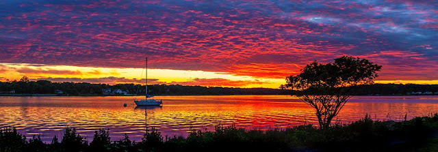
Maclearie Park is a small municipal park in Belmar, New Jersey. On one side you have a highway and the other side is the Shark River which leads into the Atlantic Ocean. Just east of the park is a marina where many charter boats dock; the marina is another great spot for sunsets but that is a story for another day. You may have already seen some of my images from Maclearie Park, if not check out Sunset and a Peek-a-Boo Moon where I not only got a sunset but the added bonus of a full moon peeking thru the clouds.

My Introduction

I have to admit that I never thought about shooting sunsets at Maclearie Park - I had been there with my kids before and have driven by countless times but, for some reason it never got on my list of places to shoot. It wasn't until Dave Schofield (you remember Dave, he was the subject of one of my most popular interviews - Interview with Sports Photographer Dave Schofield. Read it if you haven't already.) Dave shoots there frequently, as well as the marina, and has set the bar high. It has since become a "go to" spot for sunsets and I am often surprised to find new compositions after I thought I had exhausted possibilities. That is one of the wonderful, and frustrating, things about landscape photography - you never know what awaits you.

Trees

I think one of the things that makes the park such a special place to shoot are the trees - especially in silhouette. I have a favorite little tree at the far west corner of the park by a bench. This is the tree in the panorama at the top of the page and the shot with the great cloud formations on the right ("My" tree). I found this tree the very first time I went to shoot but I have since found others that I can use, depending on the conditions. It is easy to get caught up in the beauty of the sunset and focus on the colors but adding some foreground interest will really set your images apart from the rest. You can also use the trees to block out uninteresting stuff - the image above left (Sunset framed by a tree) is one that I found on my last excursion. The sky has some incredible cloud formations but there was also a large expanse of flat, gray clouds between the horizon and the interesting formations. I used this tree to hide the ugly clouds.

Look Away From the Sun

If you concentrate on the sun, you may miss out on some of the best light. The marina sits to the north of where the sun was setting, the image here was shot just a few minutes before the sun disappeared completely. I noticed the lights on the other side of the river and put on a longer lens and stopped down to f/22, knowing I would be able to turn the lights into starbursts. I also wanted the longer exposure so that I could smooth out the water as much as possible. This is one of the few "HDR" shots that I have done - I wanted a darker exposure to capture the warmth of the sky and water but I also wanted some detail in the building and shadows. This image has proven to be quite popular.

My last image for today is an example of a making lemonade when the world gives you lemons. I was at the park for what I thought would be a nice sunset but it wasn't very good. I started looking around and saw this tree with the pastel sky behind it. I was shooting towards the east, away from the setting sun and was initially struck by the muted colors.

In Closing

I hope I have inspired you to get out and shoot a sunset or two, maybe even at Maclearie Park! If you do go to Maclearie Park, I have a few suggestions:

  1. Get there early! This is especially true if it is your first time there. You want to scout the park and look for your composition. I have been there in each of the different seasons and a composition that works in the winter, may not be there in summer. It is also a popular place for people to watch the sunset so you want to stake out your territory.
  2. Bring insect repellent! Obviously, this doesn't apply year-round but definitely during spring and summer. The gnats and mosquitoes can be quite a nuisance and you will spend more time shooing them than shooting. I have been using "Deep Woods Off!" the last couple times I was there and it made a big difference.
These are just a handful of the many images I have of sunset in the park and just a fraction of the compositions available to the photographer willing to look. Have you been to Maclearie Park? If so, let me know what you think. What is YOUR favorite place for sunsets or sunrises? I am also looking for new places to shoot. So, if you find yourself in the Belmar area, looking for something to do - check out a sunset at Maclearie Park, you won't be disappointed. While you're there - if you see me, stop by and say "Hello!", I'll be the guy with the tripod and backpack.

Until next time - get out and enjoy the beauty that is nature!


All photos are copyright Joseph S. Valencia All Rights Reserved They may not be used in any way without express written permission of the photographer. If you wish to use any of the photos you may contact the photographer at valencia32photo@gmail.com

Monday, March 5, 2018

Sunset and a Peek-a-Boo Moon

Sunset

After a particularly rough day at the office I decided to shoot a sunset on the way home. The conditions were okay but I knew I wasn't going to get an incredibly spectacular sky. This shoot wasn't necessarily about getting a great image but rather unwinding and getting rid of a bad day.

When I got to MacLearie Park in Belmar I had about 30 minutes or so until sunset so I took my time finding a composition. I have shot here before but always at the westernmost point so that I can get a sailboat and small tree in the shot. I wanted something different this time so I walked along the water towards the east until I found the tree that is in the first image. I now had a subject but that is a long way from having a composition that I was happy with. I finally settled on the somewhat wide, landscape shot and waited for some color on the horizon.

While waiting, I took out my phone and wandered around - I turned towards the west and got this image of the sky. You can see the edges of the clouds just beginning to get some red and magenta along the edges. I shot this with the camera in Lightroom for Mobile, did some on-location editing and used this as my "I am here, where are you?" social media shot for the night.
I was happy with the first composition but wanted to see if I could isolate the tree a little more so I moved a bit to my left, went from wide angle to a moderate telephoto focal length and shot. I cropped it to a square in post-production and really like the way it came out. This is definitely a tree that is going to get more exposure in the coming weeks and months.

Peek-a-Boo Moon

Don’t pack up your camera until you’ve left the location. – Joe McNally
When the sun was down and I had gotten what I came for I picked up the tripod and headed back to the car. It was a chilly evening but nice so I took the long way. I had not gone far when I decided to take a look at "my" tree from the opposite side - maybe it would be a nice subject for a sunrise one of these days. I turned around and was confronted by the scene shown in the last image. The moon was peaking thru the cloud, I had the lights of the marina and bridge in the distance. I quickly set down the tripod, composed the image and grabbed a few shots before the cloud ate the moon for good.

The quote above is one that I found a while ago and I pull it out every once in a while. I used to pack up my gear when I was done shooting and then head back to my car - it was easier to carry and I could just get in the car and leave. I did this even after I saw this quote! I don't do it any more.... I had an instance where I packed up and an unbelievable composition with near perfect light jumped out at me - I grabbed by bag, set up the camera, pointed it and then muttered a few words that I won't use in polite company. The moment was gone.... I have not packed up before reaching the car ever since.


All photos are copyright Joseph S. Valencia All Rights Reserved They may not be used in any way without express written permission of the photographer. If you wish to use any of the photos you may contact the photographer at valencia32photo@gmail.com

Friday, February 16, 2018

Winter is here! Snow makes everything beautiful!

I enjoy the winter months and the snow.

Yes, you read that right - I enjoy the cold and snow. Don't get me wrong, I don't like having to drive along snow-packed, icy streets but otherwise love the snow. There is a beauty in the freshly fallen snow that calls out to me, like a siren song. I can spend hours hiking thru the woods during, and after, a snowfall.

Our First Snow

The image of Shark River Park is the first image of 2018 and shot with my smartphone on New Year's Day. I spent about 90 miles covering 2 1/2 miles hiking the woods that day - the temperature was a balmy 16°F and windchill of 0°F. That hike was more about being outdoors than photography and I never took the camera out of the bag. It has only snowed a couple of times since then but I haven't been back to the park - I like the image I got but have other compositions that I want to explore.

Snow and the Beech Tree

Beech tree - Manalapan
I recently discovered a shortcut to Monmouth Battlefield State Park, I can walk thru the office parking lot into a gated community. There is a paved path leading to a wooden footbridge, which ultimately puts you into the woods bordering the park. It was at the far end of the footbridge that I found this beech tree. I had actually passed it, unnoticed, on my way to the park but when I was returning it jumped out at me and I couldn't resist shooting. You would never know this scene is just about 40 or 50 yards from a residential neighborhood. If you look in the gap between the tree and bridge, you will see a stream that runs for quite some distance and, I believe, meets up with the water source Molly Pitcher used during the Battle of Monmouth.

Snow at the Lake

We have only had three (3) significant snowfalls this winter, the last being a couple weeks ago. This one had me the most excited because it also brought the most snow. I think I have mentioned in an earlier post that I leave quite early every morning - almost 90 minutes before I need to - so that I can take "detours" whenever the need arises. This morning I was thankful because I couldn't help but stop and shoot. I targeted Durand Park because of the lake and the one tree that leans over it. I, truly, came away with more than I was expecting to. I thought there would be ice but I wasn't expecting the part that was melted and mirror smooth. I knew these images were going to be monochrome and I was quite happy with the resulting images. That was until my son mentioned the "Winter Reflection" might look nice in a sepia tone. WHAT?! He said he had seen other black & whites images where I used the sepia and mentioned this would be a good place for it. I wasn't so sure but decided to give it a try. Well.... I think with a little bit of "tweaking" it might be a far better image in sepia. What do you think? I think I may have to consult with him a bit more often.

No session at the lake is complete without shooting this group of Aspens leaning out over the water. I have shot them in all seasons and weather conditions. There is just something about the composition that draws me in and keeps me coming back.

Don’t pack up your camera until you’ve left the location. – Joe McNally

The Joe McNally quote is one that I try to live by and is responsible for this last image. This beech tree was shot after I had finished shooting the lake and trees above. It was very cold and I was ready to get into the car and warm up. As I was walking back to the car, I noticed this tree standing alone not too far off the parking lot. The camera was already out and mounted on the tripod so it was just a matter of finding my composition and shooting. If I had been packed up I probably wouldn't have been looking for more compositions, it is also unlikely that I would taken the time to unpack and set up if I had. It's not that I am lazy but when you have been out in the elements for more than 30 minutes and are not properly dressed, you tend to want to get back inside.

So, as you can tell - I love snow! The weatherman is predicting 1 to 3 inches of wet snow Saturday night with temperatures getting into the 40's on Sunday. I am hoping to wake up on Sunday to a beautiful, snow-covered scene - I have been wanting to get back to the scene of the first image for a while but haven't had the opportunity. If we get a decent snowfall, I will post the new images here next week.

Do you like getting out in the snow? I would love to hear from you - leave a comment below and let me know your favorite snow activities or subjects to shoot.


All photos are copyright Joseph S. Valencia All Rights Reserved They may not be used in any way without express written permission of the photographer. If you wish to use any of the photos you may contact the photographer at valencia32photo@gmail.com

Wednesday, June 28, 2017

Monmouth Battlefield and the Sutfin House

Today marks the 239th anniversary of the Battle of Monmouth. I decided to mark the occasion by writing about one of my favorite photographic subject - The Sutfin House.

The Sutfin House was built in 1731 and was inhabited by Derick Sutfin, his wife, Mary and four of their eight children at the time of the battle. He was a farmer raising livestock and growing grain. He was also a slave owner and it is said that the slaves lived in the upstairs loft of the house. I became fascinated with this house from the first time I saw it while hiking the Washington Trail a few years ago. The images here are just a few of the ones I have taken - every angle in all kinds of weather. There was a time when I was shooting it nearly every day. I mostly shot from afar and have only ventured close on three occasions - twice alone and once during a paranormal investigation. Yes, I participated in a paranormal investigation and will write about that in a later post.

I will leave you with a few of the images I have made over the years and invite you to read more about the house and Monmouth Battlefield State Park on my companion blog - From the Mind of Joe Valencia. I wrote a series titled "Hiking Through History" and covered the battlefield in four parts, links are provided below.


All photos are copyright Joseph S. Valencia All Rights Reserved They may not be used in any way without express written permission of the photographer. If you wish to use any of the photos you may contact the photographer at valencia32photo@gmail.com

Featured Post

Macro (and Close-Up) Photography - A Whole New World

Macro (and Close-Up) Photography - A Whole New World All photos are copyright Joseph S. Valencia, All Rights Rese...